


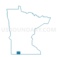
Weimer Twp. Voting District, Jackson County, Minnesota
About
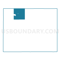
Outline

Summary
| Unique Area Identifier | 602664 |
| Name | Weimer Twp. Voting District |
| County | Jackson County |
| State | Minnesota |
| Area (square miles) | 34.66 |
| Land Area (square miles) | 31.12 |
| Water Area (square miles) | 3.54 |
| % of Land Area | 89.78 |
| % of Water Area | 10.22 |
| Latitude of the Internal Point | 43.80972590 |
| Longtitude of the Internal Point | -95.26995740 |
Maps

Graphs
Select a template below for downloading or customizing gragh for Weimer Twp. Voting District, Jackson County, Minnesota


Neighbors
Neighoring Voting District (by Name) Neighboring Voting District on the Map
- Alba Twp. Voting District, Jackson County, MN
- Delafield Twp. Voting District, Jackson County, MN
- Great Bend Twp. Voting District, Cottonwood County, MN
- Heron Lake Voting District, Jackson County, MN
- Heron Lake Twp. Voting District, Jackson County, MN
- La Crosse Twp. Voting District, Jackson County, MN
- Springfield Twp. Voting District, Cottonwood County, MN
- West Heron Lake Twp. Voting District, Jackson County, MN
- Wilder Voting District, Jackson County, MN
Top 10 Neighboring County Subdivision (by Population) Neighboring County Subdivision on the Map
- Heron Lake city, Jackson County, MN (698)
- Heron Lake township, Jackson County, MN (333)
- Great Bend township, Cottonwood County, MN (287)
- Delafield township, Jackson County, MN (226)
- West Heron Lake township, Jackson County, MN (181)
- Alba township, Jackson County, MN (170)
- La Crosse township, Jackson County, MN (156)
- Weimer township, Jackson County, MN (142)
- Springfield township, Cottonwood County, MN (120)
- Wilder city, Jackson County, MN (60)
Top 10 Neighboring Place (by Population) Neighboring Place on the Map
Top 10 Neighboring Unified School District (by Population) Neighboring Unified School District on the Map
- Jackson County Central School District, MN (7,797)
- Windom Public School District, MN (6,014)
- Heron Lake-Okabena School District, MN (1,658)
Top 10 Neighboring State Legislative District Lower Chamber (by Population) Neighboring State Legislative District Lower Chamber on the Map
Top 10 Neighboring State Legislative District Upper Chamber (by Population) Neighboring State Legislative District Upper Chamber on the Map
Top 10 Neighboring 111th Congressional District (by Population) Neighboring 111th Congressional District on the Map
Top 10 Neighboring Census Tract (by Population) Neighboring Census Tract on the Map
- Census Tract 2703, Cottonwood County, MN (3,220)
- Census Tract 4802, Jackson County, MN (2,293)
- Census Tract 4801, Jackson County, MN (2,276)